
Telok Blangah forest walk
(Somehow I managed to forget to write this day up at the appropriate time. This dates from before I moved on to KL, of course.)
One of the things I had wanted to do last year but never managed was to walk along the Southern Ridges. This is a laid-out path (or series of paths) that link a number of open spaces just behind the south coast of Singapore island. It stretches a few miles – I joined it at Kent Ridge which is not the westernmost end of it, and walked through Hort Park, Telok Blangah, Mount Faber, and finally down the Marang Trail back to the MRT. These areas are all green (in different ways) and in some cases quite hilly, but are all separated by busy roads; but since the creation of the Southern Ridges walk, they’re all connected by paths running above the roads – in a couple of cases, dramatically high above the roads.
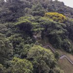
I got there by MRT to Pasir Panjang, then walking back eastwards along a busy road to a Pepys Road which leads off to the north side of the busy road, and then walked up Pepys Road until I reached the edge of Kent Ridge. This was actually at the eastern end of Kent Ridge, so initially I walked westwards for a half-a-mile or so, fully in the knowledge that I would be retracing my steps in a short while. I was a bit disappointed to find that the Kent Ridge Forest Walk (a tree-top high level walkway) was closed for maintenance, but it turned out that there were other high-level walkways later. Kent Ridge was quite manicured, and I stopped and started retracing my steps when it became obvious that I was approaching an area that looked more like a park. I did reach a viewpoint and was taken by an old information board that showed an explanatory picture of the view. However, the board hasn’t been updated for quite a few years, and the view has changed a lot….
-
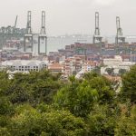
- View from Kent Ridge viewpoint
-
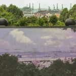
- Old picture of the same view!
-
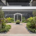
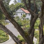
- The English Garden, HortCentre
I found a path dropping quite steeply to Hort Park, the next open area eastwards. This was very different from any of the other areas I walked across. While it’s green it’s not really open – instead, it seems to be a cultivated area with a number of nursery gardens. I think that Gardens by the Bay grow plants here in a series of controlled-environment greenhouses, and there also seem to be community gardens that looked for all the world like a Singaporean version of English allotments. There was also a busy public area, the HortCente, which looked like a combination of a community centre, shops, restaurants and other small-scale facilities. I particularly liked the ‘English Garden’ here – a small area laid out in formal English garden style, but with (mainly) tropical planting. I also recall that somewhere in Hort Park there was a large, sheltered (i.e. covered) facilities area with toilets, water fountains and vending machines – this was very welcome.
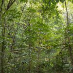
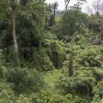
After Hort Park there was a steep climb towards the next area, Telok Blangah Hill Park. This began with an elevated crossing of Alexandra Road, a very busy dual carriageway that I wouldn’t have wanted to cross at ground level, and then continued with about 2.5kms of elevated walkway high up in the trees. This was very impressive. The surroundings were very forested, almost jungle-y. I don’t know of this is a small area of residual forest or whether it has been allowed to regenerate, but it’s in stark contrast to most of Singapore and I enjoyed it very much. It’s also worth saying that it was probably more enjoyable walking through it 20 mtrs up in the air than it would have been at ground level.
-
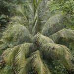
- Forest
-
- Forest and access path
-
- Near Alexandra Road
-
- Forest
-
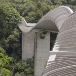
- Henderson Waves
-
- Forest
I took my time over this stretch – I was very surprised at how wild the forest looked. I also had a couple of conversations with other walkers along here (people seemed keen to stop and chat) – once with an English party who were talking about birds, and again with a Singaporean gentleman who was interested in my camera and with whom I had a good conversation about photography.
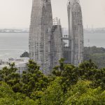
Telok Blangoh Forest Park is linked to Mount Faber, the next green area, by the Henderson Waves, a wonderful steel, concrete and wood structure that connects these two areas at a very high level – about 36mtrs above Henderson Road, another busy road.
-
- Forest and Hi-Rise from Mount Faber
-
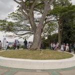
- Mount Faber peak and people
-
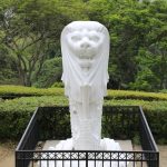
- Merlion at Mount Faber peak
Mount Faber was more of a park than Telok Blangah, and I was back on roads, but I pressed on hoping to reach Mount Faber Peak. Well, I did, and to my surprise found it to be very busy with visitors, who from the way they were dressed had not walked very far to get there! Indeed, I soon found that there is a road almost to the top, and the peak is a popular stopping point for coach excursions.
The last section was a steep drop down the Marang Trail back to a busy road and the Harbourfront MRT station. I took a few minutes to rest before boarding a train. As with other activities I’d undertaken (e.g. the zoo) I’d got very hot and had sweated a lot during the walk, and it was only as I was returning to civilisation that it struck just how much of a mess I must look! – not someone that the elegant and well-dressed Singaporean women would want too close to them on the MRT. So I took a five-minute rest inside the air-conditioned MRT station to cool down and tidy myself up a bit. By the time I boarded the train at least I’d stopped dripping.
This was a hard morning/early afternoon, but very enjoyable, in a masochistic way. It was as hot and humid as usual, of course, and I was out in it and exercising, but the surroundings were interesting enough to distract me from my discomfort. I’m glad I did it. On a practical point, this was one of the times when I wore a pair of shorts, and I also wore a very light short-sleeved top. On my feet I wore walking shoes. Perhaps not really necessary as the walk was entirely along solid paths, but the walking shoes were very comfortable and it least it meant that I had clean, fresh footwear to change into later. I also took a hat, and anointed myself with liberal amounts of Factor 30 suncream before leaving the hotel and with insect repellent at the start of the walk. These both worked well throughout the holiday in fact – I returned home no pinker than when I left and untroubled by insect bites.
Leave a Reply