In my last post, ‘Travels of a Laptop‘, I briefly mentioned that on its journey from South Korea to Germany, the package that contained my new laptop followed a Great Circle Route. I didn’t however explain what they are, and why they’re significant.
For most of us, the usual map of the world that we look at is based on the Mercator Projection. This preserves accurate latitude distances – that is, North/South distances – but distorts Longitude. 1˚ of Latitude is always the same distance, both on the map and on the actual globe, but 1˚ of Longitude will vary on the globe depending on your latitude. We all know that there are 360˚ in a circle, which means that at the equator the length of 1˚ of longitude will be the circumference of the earth at the equator (about 24,900 miles) divided by 360, or just over 69 miles. But at a latitude of 45˚ (North or South) the circumference of the earth is only about 17,637 miles. Therefore at that latitude, 1˚ of Longitude is 17637 miles/360, which is about 49 miles – less than it is at the equator. Unfortunately the Mercator Projection doesn’t show this at all, and therefore the further away from there equator, the more the map distorts reality. This has two distinct effects on what we see on the map and possibly on how we think.
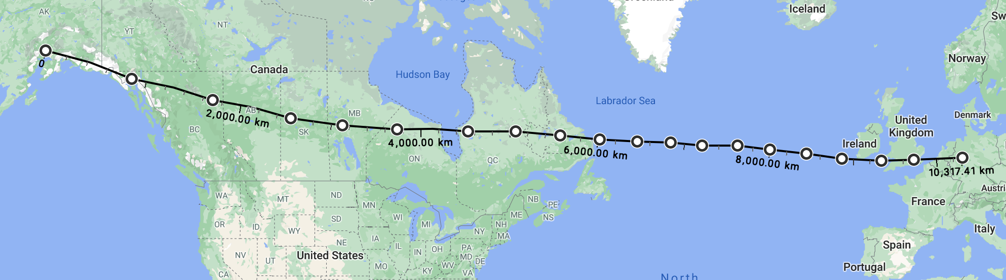
The first relates to distances and directions. As I mentioned in that earlier post, one stage in my laptop’s journey was from Anchorage, Alaska to Cologne in Germany. The image below shows the route you might expect it to take between those two points. I’ve created as near a straight lines as I could on the Google Maps image, and that route works out at 6,410 miles.
In fact the route taken was very different, and below are two images showing that route. First is how it looks on a standard Mercator map: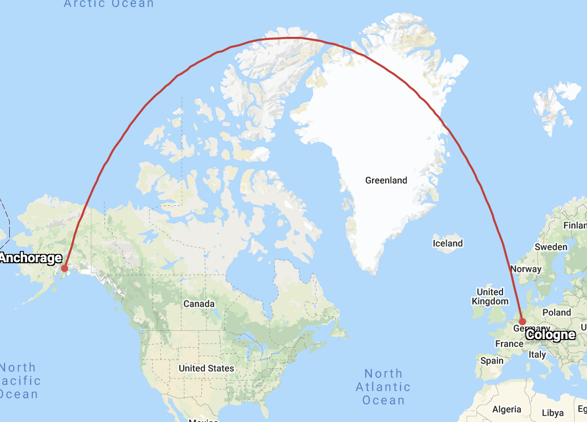
That looks truly odd; why would it take that strange curving route instead of the straight line? Well, actually it was a straight line, as this third image shows.
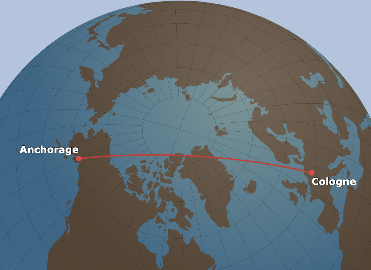
That’s the Great Circle route – the shortest route around the curvature of the globe – and you can see that it is in fact pretty close to a straight line. Furthermore it’s shorter than the first route I traced out – 4,600 miles as against 6,400 miles, or 1,800 miles shorter. That’s more than three hours’ flying time, and a whole lot of fuel.
In the next post I’ll show you how the Mercator Project distorts the size of countries, and makes those closer to the either pole look much bigger than they actually are. In the meantime here’s a link to the website (greatcirclemap.com) from where I got the two images above. You can make your own maps – just enter the starting and finishing airports, and use the buttons over on the r/hand side to see the difference between the great circle route and the apparent route on a Mercator map.
Leave a Reply